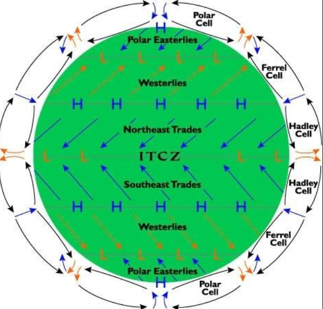
1. What happens at the inter tropical convergence zone?
A. The southwest and northwest trade winds converge
B. The southwest and northwest trade winds diverge
C. The southeast and northeast trade winds converge
D. The southeast and northwest trade winds converge
Solution
The correct answer is The southeast and northeast trade winds converge.
Key Points
- The Intertropical Convergence Zone (ITCZ) is a belt of low pressure which circles the Earth generally near the equator.
- Here, the southeast trade winds originating from the Southern Hemisphere meet the northeast trade winds from the Northern Hemisphere.
- These trade winds converge, or come together, at the ITCZ causing the air to ascend.
- This is because when these winds meet, they have nowhere to go but up due to the surface convergence.
- The upward movement of air leads to the formation of clouds and precipitation, making the ITCZ an area of high rainfall.
- The location of the ITCZ can vary seasonally, and it significantly influences global weather patterns.
Additional Information
| Wind | Description |
|---|---|
| South-West Monsoon Winds | These winds originate from the Indian Ocean and Arabian Sea, and bring heavy rainfall to most parts of India from June to September. They are responsible for the main rainy season in India, known as the southwest monsoon season. |
| North-East Monsoon Winds | These are also known as the winter monsoons. They flow from the land to the sea, largely affecting the Coromandel coast and Tamil Nadu from October to December, where they bring the majority of annual rainfall. |
| Loo Winds | These are strong, gusty, hot, and dry winds that blow during the day over the North Indian plains from April to June. They can be harmful to humans and animals due to their extremely high temperatures and low humidity. |
| Western Disturbances | These are weather phenomena originating from the Mediterranean region that bring winter and pre-monsoon season rainfall to the North-Western parts of India. These are essential for the rabi crops. |
| Trade Winds | These are not unique to India but are global wind systems. In the Indian Ocean region, these winds are from the northeast in the Northern Hemisphere and from the southeast in the Southern Hemisphere. They contribute to the monsoon winds. |
2. Which place’s distribution of pressure influences the weather conditions over India in winter?
A. Antarctica
B. Central and Western Asia
C. South East Asia
D. North America
Solution
The correct answer is Central and Western Asia.
Key Points
- Central and Western Asia is known for the formation of a high-pressure area during winters, which causes cold and dry winds to blow towards India.
- These winds are known as the northwestern winds or the ‘winter monsoon,’ and they bring in cold and dry air, resulting in a decrease in temperature over the Indian subcontinent.
- The high-pressure area over Central and Western Asia is caused due to the cooling of the landmass during winters.
- As the land cools down, the air above it also cools down and becomes denser, leading to the formation of high pressure.
Additional Information
- Antarctica is located at the southernmost part of the Earth and has little or no influence on the weather conditions over India in winter.
- Since they don’t usually deliver significant weather, winter monsoons are less well-known.
- But they also blow a lot of dry air from the interior of a continent, which can cause crop failure, drought, and water shortages.
- The northeast rains, also known as the winter monsoon, are important in Tamil Nadu, the Andhra Pradesh coast, Kerala, the north of Karnataka, and Lakshadweep.
3. Which of the following statements about permanent winds is correct?
A. These blow only during a particular period of the day in a small area.
B. These winds change their direction in different seasons.
C. These blow constantly throughout the year in a particular direction.
D. Monsoon is an example of permanent winds.
Solution
Permanent winds blow constantly throughout the year in a particular direction.
Key Points
- The movement of air from high pressure area to low pressure areas are called Winds.
- Winds are classified into three types:
- Permanent winds
- Seasonal winds
- Local winds
- Permanent winds blow throughout the year in a particular direction.
- The trade winds, the westerlies and the easterlies are examples of permanent winds.
- Local winds blow during a particular period of the day in a small area.
- Seasonal winds change their direction in different seasons.
- Monsoon is an example of seasonal winds.
Thus, we can say that permanent winds blow constantly throughout the year in a particular direction.
4. In which of the following regions, rainfall occurs mainly during winters ?
A. Mediterranean Region
B. Savanna Grassland Region
C. Subtropical Region
D. Monsoon Asia Region
Solution
The correct answer is Mediterranean Region.
- The Mediterranean Sea has the greatest extent of this type of ‘winter rain climate’, and gives rise to the name Mediterranean Climate.
- The Mediterranean climate is usually characterized by rainy winters and dry, warm to hot summers.
- An area of tropical monsoon climate (occasionally known as a sub-equatorial, tropical wet climate or a tropical monsoon and trade-wind littoral climate) is a tropical climate sub-type that corresponds to the Köppen climate classification category Am.
- The tropical monsoon climate is the intermediate climate between the wet Af (or tropical rainforest climate) and the drier Aw (or tropical savanna climate).
5. Which of the following is NOT the correct match for climate regions proposed by Koppen?
A. Aw – Southern Rajasthan
B. Cwg – North Rajasthan
C. BWhw – Dry desert
D. Bshw – Semi Arid desert
Solution
The correct answer is Cwg – North Rajasthan.
- Cwg – North Rajasthan is NOT correctly matched.
Key Points
- Koeppen’s classification in Rajasthan:
- BWhw Climatic Region:
- The region has an arid-hot desert climate with very scanty rainfall.
- Precipitation is very less and evaporation is very high.
- Thus, these areas are known as desert regions, limited to western parts of the Thar Desert.
- Extension – Jaisalmer, Bikaner,
- Partial part – Sri Ganganagar, Hanumangarh, Churu.
- Bshw Climatic Region:
- This climatic region is semi-arid, where winters are dry and even in summers there is no sufficient amount of rainfall.
- Vegetation is of steppe type, characterized by thorny bushes and grasses.
- Extension – Luni Basin, Ghaggar Basin, Nagaur, Shekhawati.
- Cwg Climatic Region:
- The areas east of Aravalli are part of the region.
- Extension – Alwar, Bharatpur, Karauli, Jodhpur, Rajsamand, Sirohi, Sawai Madhopur, Tonk, Udaipur, Jaipur.
- Aw or Tropical Humid Region:
- The southern parts of the Dungarpur district and Banswara come under the region.
- Here, tropical grasslands and Savanna regions are found along with deciduous trees of the Monsoon type.
- Extension – Kota, Baran, Jhalawar, Dungarpur, Banswara, Pratapgarh, Mount Abu.
- BWhw Climatic Region:
6. Which districts come in the Bwhw climate region?
A. Jaisalmer, Bikaner, Ganganagar
B. Jaipur, Dausa, Alwar
C. Kota , Bundi, Jhalawar
D. Nagore, Pali, Jalore
Solution
The correct answer is Jaisalmer, Bikaner, Ganganagar.
Key Points
- According to Koppen classification, the climate of Rajasthan is divided into 4 parts
- Aw- Tropical wetlands
- Bshw- Semi-arid region
- Bwhw- Hot-arid region
- Cwg- Mansoon rainy region
Additional Information
| Type of Koppen Climate | District |
| Aw | Dugarpiur, Banswara, South Chittorgarh, And area of Jhalawar district |
| Bshw | West area of Aravali |
| Bwhw | Jaisalmer, Bikaner, Ganganagar, Hanumangarh,and some area of churu |
| Cwg | East and middle part of Rajasthan and Eastern Part of Rajasthan |
7. A parcel of air always moves from
A. High pressure to low pressure
B. Low pressure to high pressure
C. Low pressure to low pressure
D. High pressure to high pressure
Solution
The wind is the movement of air caused by the uneven heating of the Earth by the sun.
Key Points
Characteristics of wind:
- Wind has two important characteristics direction and speed.
- The wind is moving air and is caused by differences in air pressure within our atmosphere.
- Air under high pressure moves toward areas of low pressure.
- The greater the difference in pressure, the faster the air flows.
- The direction of the wind is expressed as the direction from which the wind is blowing.
- For example, easterly winds blow from east to west, while westerly winds blow from west to east.
- Winds have different levels of speed, such as “breeze” and “gale”, depending on how fast they blow.
- Wind speeds are based on the descriptions of winds in a scale called the Beaufort Scale, which divides wind speeds into 12 different categories, from less than 1 mph to more than 73 mph.
Hence option 1 is the correct answer.
8. Where does the El Niño current flow?
A. The Pacific Ocean
B. The Indian Ocean
C. The Bay of Bengal
D. More than one of the above
Solution
The correct answer is The Pacific Ocean.
Key Points
- The El Niño current is not a traditional ocean current like the Gulf Stream or the California Current. Instead, it is part of the El Niño-Southern Oscillation (ENSO) climate pattern, which involves changes in ocean and atmospheric conditions in the tropical Pacific Ocean.
- During an El Niño event, warm waters from the western Pacific Ocean move eastward and flow along the equator towards the coast of South America. This warm current can disrupt normal weather and ocean patterns, leading to various climate-related effects around the world.
- It’s important to note that El Niño is just one phase of the ENSO, with La Niña being its counterpart, where cooler waters dominate the central and eastern Pacific.
- The specific path and strength of the El Niño current can vary from one event to another, but it typically flows from west to east along the equator in the tropical Pacific Ocean, affecting weather and climate patterns in different regions, including the Americas, Australia, and Asia.
- El Nino was first recognized by Peruvian fishermen off the coast of Peru as the appearance of unusually warm water.
- The Spanish immigrants called it El Nino, meaning “the little boy” in Spanish.
- El Nino soon came to describe irregular and intense climate changes rather than just the warming of coastal surface waters.
- The El Nino event is not a regular cycle, they are not predictable and occur irregularly at two- to seven-year intervals.
- The climatologists determined that El Nino occurs simultaneously with the Southern Oscillation.
- The Southern Oscillation is a change in air pressure over the tropical Pacific Ocean.
- When coastal waters become warmer in the eastern tropical Pacific (El Nino), the atmospheric pressure above the ocean decreases.
- Climatologists define these linked phenomena as El Nino-Southern Oscillation (ENSO).
Additional Information Impact of El Nino: In order to understand the concept of El Nino, it’s important to be familiar with non-El Nino conditions in the Pacific Ocean.
- Normally, strong trade winds blow westward across the tropical Pacific, the region of the Pacific Ocean located between the Tropic of Cancer and the Tropic of Capricorn.
- Impact on Ocean: El Nino also impacts ocean temperatures, the speed and strength of ocean currents, the health of coastal fisheries, and local weather from Australia to South America and beyond.
- Increased Rainfall: Convection above warmer surface waters brings increased precipitation. Rainfall increases drastically in South America, contributing to coastal flooding and erosion.
- Diseases caused by Floods and Droughts: Diseases thrive in communities devastated by natural hazards such as flood or drought.
- El Nino-related flooding is associated with increases in cholera, dengue, and malaria in some parts of the world, while drought can lead to wildfires that create respiratory problems.
- Positive impact: It can sometimes have a positive impact too, for example, El Nino reduces the instances of hurricanes in the Atlantic.
- In South America: As El Nino brings rain to South America, it brings droughts to Indonesia and Australia.
9. Which of the following is a local wind of USA?
A. Chinook
B. Foehn
C. Harmattan
D. Mistral
Solution
The correct answer is Chinook.
Key Points
- Chinook is a local wind of USA
- Chinook winds develop in the northwest region of North America.
- Chinook is a beneficial wind
- The Rocky Mountains is the specific regions for the Chinook.
- Foehn is a hot wind of local importance in the Alps.
- Foehn is also a beneficial wind.
- Mistral is a harmful wind.
- Mistral is very cold and dry at a high speed.
10. Eskimos” are associated with which geographical region?
A. Arid Region
B. Polar Region
C. Savanna Grassland
D. Tropical Rainforest Region
Solution
The correct answer is Polar Region.
Key Points
- Eskimos are the indigenous circumpolar people who have traditionally inhabited the northern circumpolar region from eastern Siberia (Russia) to Alaska (United States), Canada, and Greenland (Denmark).
- Polar Region
- The part of the Earth’s surface forms a cap over a pole; characterized by a frigid climate.
- There are two main polar regions in the world, which are the Arctic and the Antarctic.
- The Arctic Circle and Arctic Tundra are found at the North Pole, and it covers nearly 5 million square miles of the
- top of the Northern Hemisphere.
Additional Information
- Arid Region
- An arid region, also known as a desert, is defined by a severe lack of available water, to the extent of hindering or preventing the growth and development of plant and animal life.
- This harsh environment is typically characterized by extremely low rainfall, high temperatures, and high evaporation rates.
- Due to the scarcity of water, the biodiversity in arid regions is lower compared to other ecosystems.
- Savanna Grassland
- Savanna grasslands in Brazil are called Campos.
- These grasslands lie between 24°S and 35°S, which includes Uruguay and parts of Paraguay, Brazil, and Argentina.
- These are rich in plant species and are more diverse than forest ecosystems.
- The climate here is subtropical humid and the rainfall is distributed regularly all over the year.
- A grassland is an area that mostly comprises grasses.
- Tropical Rainforest Region
- The tropical rainforest is a forest with tall trees in a region of year-round high temperatures where an average of 50 to 260 inches of rain falls yearly.
- The tropical rainforests are confined to areas of heavy rainfall.
- Such areas are in the Western Ghats, upper parts of Assam, Tamil Nadu coast, and the island groups of Lakshadweep and Andaman & Nicobar.
- Areas that receive more than 200 cm of rainfall and have a short dry season are the best area for the tropical rainforest.